


This article may contain affiliate links, which means that I may earn a small commission, at no cost to you, for qualifying purchases. I only recommend products or sites that I have used and personally love!
The “Mighty Five”, the Ultimate US Roadtrip, Sights you Must See Before You Die- any google search will tell you this area of the Southwest United States is a must see. Basically you need to take this road trip. Seriously.
Conquering all the major stops in the Southwest US can be an overwhelming trip to plan, I get that. It’s a really big area and there’s so much to see you may feel nervous that you’re going to do it “wrong.” I am going to break it down into a series of articles about each major stop along the route, then summarize with the Ultimate Road Trip Itinerary, which will take you about 10 days. You can choose to conquer the entire loop in one vacation as we did, or pick one of the stops as a destination all on it’s own.

Let’s start with Zion National Park with a side trip to Valley of Fire State Park. Zion National Park is absolutely beautiful and has so much to offer. People name their kids Zion after this park, it’s just that amazing!
Check out my complete Ultimate Southwest US Roadtrip Itinerary HERE!
GETTING THERE
If you are flying to Zion you have alot of choices so be sure to compare prices, but generally the smaller airports, which unfortunately are the closest, will usually be the most expensive. I love to follow Scott’s Cheap Flights, Expedia, and Hopper to track prices and know when and where to buy!
Check out my blog “Travel Within YOUR Budget” for more great money saving tips!
- St. George Regional, Utah- 1 hour drive
- Cedar City Regional Airport, Utah- 1 hour 10 minute drive
- McCarran International Airport Las Vegas, Nevada- 2 hours 45 minute drive
- Bryce Canyon Airport, Utah- 2 hours 45 minute drive
- Salt Lake City, Utah- 4 1/2 hour drive
- Furnace Creek Airport, Death Valley California- 4 hours 40 minute drive
We chose to fly in and out of Las Vegas. We found a very affordable flight, and many competitive rental car options, plus it’s an easy drive to our starting point! We picked up our rental car and hit the road for our great American road trip adventure!
Tip Alert! I always place an online grocery order before we arrive for pickup on our way. No one wants to spend time grocery shopping, especially in an unfamiliar store. This way you get your essentials and get on the road! For this trip I checked this Arctic Cooler as baggage and then filled it with our grocery supplies. I used a Las Vegas Walmart for an online grocery order with curbside pick up super close to the airport. Groceries are often more expensive and slimmer pickings as you head into any of the touristy gateway towns.
Leaving Las Vegas you’ll hit the road toward Zion National Park, your first major stop, but first break up your drive with a stop at Valley of Fire State Park.
Drive Times:
Vegas to Zion 3 hours
-Vegas to Valley of Fire 1 hour
-Valley of Fire to Zion 2 hours
I have some strong feelings about Valley of Fire. Is it beautiful? Unique? Yes it’s both of those things. Do I recommend it? Sort of. Whenever we talk about this trip we accidentally call it Death Valley, I think that’s our subconscious reminding us how we felt about it! We always refer to it as the hottest we’ve ever been. Like hotter than anyone should ever be. Now mind you we did this trip in July and the legit temperature was 114 degrees. This park does not have any shade, which is true for most of the American Southwest. We weren’t just uncomfortably hot, it was dangerously hot. This is a beautiful park, especially Fire Wave. I would love to explore this area in the winter or an overcast day but it caught us off guard and was really, really hard!!

Stop by Valley of Fire State Park: $10 entrance fee (FYI your national park pass doesn’t work here since it’s a state park)
–Atlatl Rock: This is a large rock with petroglyphs drawn 4,000 years ago. The nerd in me absolutely loves petroglyphs I find them so fascinating!! You can drive to Atlatl Rock and walk up a lot of steps to see the carvings.

Still Smiling at 114 Degrees 
Fire Wave 
I may be smiling but I’m dying inside at Fire Wave- Valley of Fire
–Fire Wave: The Fire Wave area is really what Valley of Fire is famous for, thanks to Instagram and all of the gorgeous images. It is only a 1.5 mile route round trip with a small elevation gain of 180 feet, but friend please don’t underestimate this. There’s something about that dry heat and no shade that made this one of the hardest things my family has ever done and I would not do it again if the temperature is 114 degrees! It is however an extraordinarily beautiful and very unique area.
To get to Fire Wave from the visitor center you should take White Domes Road/Mouse’s Tank Road into the park for 4.7 miles. Park in parking lot #3. The trailhead is across the street from the parking lot. There is cell reception at parking lot #3. You’ll want to allow about an hour for the Fire Wave area, and bring LOTS of water!
–Pink Pastel Canyon- This looks gorgeous in photographs and is said to be easy but we absolutely could not find it! We were also an inch of our lives after surviving Fire Wave so we didn’t try that hard. It is a small unmarked canyon with pink walls, it isn’t on any official park materials so few people know it is there.
Here’s what my research on it tells me: It is said to be beautiful and easy. From the Visitor’s Center take White Domes/Mouse’s Tank Road for 4.1 miles. You will cross a number of large obvious dips in the road, at dip #5 you can park on the right side of the road (the east side) onto the shoulder area. Walk east into the wash area located just off the road, then immediately turn north and walk up the wash and you’ll see the pink canyon entrance where you can walk in and start exploring. After it opens up it should lead to Fire Wave. BUT as I said earlier we still couldn’t find it. If you’re able to find it please let me know if it is amazing!!
–Rainbow Vista: This offers beautiful views of the park. You can simply pull over and take in this view of vibrant colors of a land where dinosaurs once roamed.

Continue on to Zion National Park, spend the night in Zion
-Drive time from Valley of Fire 2 hours
Now let’s hit the road in our wonderfully air conditioned car and head to Zion National Park!
Zion National Park, Utah
Zion National Park is one of my absolute favorite places!! I seriously love it so much. I don’t feel like we had enough time there on this trip so I definitely want to go back and spend several days exploring this fantastic park! We spent two nights here, if you have more time on your trip this is definitely a spot I would recommend adding days to!
Tip Alert! The entrance fee into Zion National Park is $35 per car which is good for 7 days, but if you plan on going to more than one national park during the year you may as well purchase an America the Beautiful Pass for $80, it includes unlimited entrance into ALL of the national parks for a whole year! You can purchase from the National Park Service, at the park gate, or what I usually do is purchase ahead of time from REI.
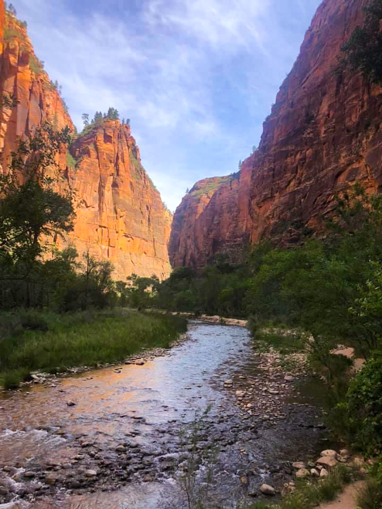
The Narrows Hike
In my opinion this is the #1 thing to do in Zion. If it’s open just make it happen! This is a 6 mile hike through the shallow Virgin River as it runs between the the vibrantly colored walls of the narrowest section of Zion Canyon. The reason I say to do it “if it’s open” is because it closes often. If there’s any rain in the forecast rangers will close this trailhead for safety because no one wants to get stuck in a slot canyon during a flash flood with no way out! Yikes.
The water varies from shallow to waist deep over the course of the hike. Since this is an in/out trail you do not have to do the entire 6 miles but can turn around whenever you want. I would recommend going at least until the section where the canyon walls really narrow, which took us about 2 hours out. This section is called the Orderville Canyon.

WHAT TO KNOW:
Getting to the trailhead take some prior planning. Parking is extremely limited inside the park and fills up very early, like the crack of dawn early. You can park in the town of Springdale and catch a shuttle from town to the Zion Visitor Center and then take another park shuttle from there to the trailhead. The visitor center lot is large so you can also park there to catch the inside the park shuttle. Visit HERE for the most up to date shuttle info including schedule and parking info. The parking/shuttle stop for the Narrows is called the Temple of Sinawava where you’ll access the Riverside Trail, a 1 mile flat paved walk that will end where the Narrows water begins.
When we visited Zion National Park the shuttle was not operational due to Covid 19 and parking was said to fill up by 4:00am! We stayed inside the park so that solved our parking issue. But, how would we get to the trailhead without a shuttle? Thank you for asking. We rented bicycles!


We rented bicycles from
Zion Adventures
If biking is your thing this is a great way to explore the park! We rented our bicycles and hiking gear from Zion Adventures. I probably had not ridden a bike in 30 years so I practiced at home before we went but I really sucked at it. My poor family. We got there though (eventually) and that’s all that matters!


GEAR NEEDED FOR THE NARROWS:
The recommended gear for the Narrows varies and really depends on what time of year you hike. If you’re hiking in the fall or winter then you would want to rent a dry suit or wet suit package which also includes your canyon shoes. We were there in the middle of summer so we only worried about our cold wet feet and traction. Some members of my family rented the footwear package which includes waterproof neoprene socks, canyon shoes, and hiking poles for $27 from Zion Adventures, while others just wore old hiking boots and regular socks, and honestly we were all fine. I would definitely advise against any open toe shoes even if they are water sandals like Chacos. I love my Chacos but there is debris in the water that will drive you nuts if its constantly getting in your shoes. You will definitely want some shoes with good traction like waterproof hiking boots or a pair of old hiking boots that you don’t mind getting wet, and won’t need to wear over the next few days until they dry! I wore these Moab Merrill Hiking Boots and they were amazing.
When I was trying to decide about hiking sticks I talked it over ahead of time with a tour guide who said walking the narrows is alot like walking on bowling balls under water, and she was absolutely correct. That is exactly what it is like! I definitely recommend hiking poles! You can rent them from many of the area outfitters or purchase some like we did from Amazon. After some research I found we could purchase THESE POLES from Amazon for the same price as renting, then we would have them for future hikes! If you have room in your suitcase I say buy them, they saved my tail multiple times!
Canyon Overlook Point
This is a beautiful hike that you can only reach with the help of your own vehicle. You would drive on the Zion-Mount Carmel Highway through the tunnel to reach the small car park by the start of the Canyon Overlook Trail. If you have a large RV you will have to pay a small fee as the tunnel is very narrow and will have to be closed one way for you to pass. Once you reach the car park, leave your vehicle and head onto the trail! The trail is just 0.5 mile and has a gradual elevation gain, it is physically a pretty easy and fun trail but there are definitely some major drop offs that are scary! I would not recommend this for young children or anyone scared of heights. Many sites recommend this as a great sunset spot and I am sure it is beautiful at sunset, when we hiked to the Overlook Point many people were spread out on blankets waiting for the sunset but I would point out that you do not want to hike back to your car in the dark on this trail because of the drop offs.


Other Recommended Hiking Trails
We didn’t have an opportunity to do all of these trails but they all came up on my research as great options. I definitely want to go back and check them all off my list! If you’ve done any of them let me know what you thought!
Easy hikes:
- Pa’rus Trail- This trail is right next to the main entrance of the park. It is 3.3 miles round trip with an elevation gain of 223 feet. The trail has several footbridges and meadows, as well as spots to wade into the Virgin River.
- Riverside Walk- This is also the gateway to the Narrows. It’s a 1 mile flat paved trail that leads to the beginning of the Narrows.
- Emerald Pools- Lower Emerald Pool is a paved 1.3 mile round trip hike with an elevation gain. of 154 feet. This is an easy hike that leads to the Lower Emerald Pool and a small waterfall
- Watchman Trail- This is a great alternative to the very difficult Angel’s Landing hike. It is a moderate hike with a 600 foot elevation gain over 3.2 miles round trip.
- Weeping Rock- This trail is only .4 miles long but has an elevation gain of 174 feet during that short hike so it is steep. Much of this trail is in the shade, and it offers amazing views down into Zion Canyon.
- Canyon Overlook- This is a short 1 mile trail without much elevation gain but it does have some steep drop offs and slick areas! See my complete description above.
- Narrows- Hike as far as you want through the shallow waters then turn around, see my detailed description above.
Difficult Hikes
- Angels Landing- This is listed as a strenuous 5.4 mile hike with a 1,500 foot elevation gain. It’s the most “thrilling” hike in the park with huge drop offs (read scary as heck) It is said to reward you with amazing 360 degree views.
- Observation Point Trail- This is Zion’s longest hike at 8 miles and has a difficult elevation gain of 2,000 feet! It is considered a classic in the park with dramatic views.
- Hidden Canyon- This is a 2.9 mile hike with an elevation gain of 940 feet. It is less crowded than Angel’s Landing. It is a narrow “thrilling” trail with some steep drop offs and culminates in a canyon trail at the end. This trail does require some rock scrambling!
Best Sunrise locations:
- Bryce Point- Gorgeous and not as crowded as some other areas
- Temples of the Virgin- Located behind the history museum
- Canyon Overlook Trail- See my full description above for this hike. You’ll have to get an early start to experience it at sunrise!
Best Sunset Spots:
- Kolab Canyons Viewpoint- Drive to the Kolob Canyons section of Zion for amazing panoramic views of the Kolob Finger Canyons. The view is from the parking lot and is one of the best in the park, no hiking is needed!
- Pa’rus Bridge/Canyon Junction- You can follow the Pa’rus trail from the main parking lot to get to the Canyon Junction bridge. There are a few other pedestrian bridges along the Pa’Rus trail which are also excellent to watch the sunset from.
WHERE TO STAY:
There are a variety of hotel options just outside the park in the town of Springdale. We chose to stay in a Western Cabin inside the park. The cabins are so quaint you feel like you’re at camp, and offer amazing views! The only option for booking is directly through the Zion Lodge website. Book far in advance, accommodations inside the park can book up to a year in advance!

Western Cabin is a great lodging option inside ZionNational Park
WHERE TO EAT
- Zion Pizza & Noodle Company located in the cute town of Springdale. It was delicious! Super good pizza and a fun atmosphere, with a great beer selection. It does get very crowded with a long wait so try to go at an off time.
- Oscar’s Cafe located in the town of Springdale, this restaurant has a Mexican flair but offers great variety. It’s a fun and funky atmosphere with lots of outdoor seating. Oscar’s serves breakfast, lunch, and dinner. It is the best rated restaurant in Zion with menu offerings ranging from burgers to sweet potato burritos, and amazing views!
- Stop by the Springdale Candy Company for homemade ice cream and hand dipped chocolates!
- We ate breakfasts in our room and packed picnic lunches everyday with supplies from our cooler. This is a great way to save money and time. The lines are always long within the park, the food overpriced, and in general all national parks are known for their mediocre food options.
WHATS IN YOUR SUITCASE?
This isn’t everything you’ll need for your Southwest US Road Trip but it’s some of the major things that you may forget and then regret!
- Bug Spray– This is the bug spray we always travel with, it is all natural and has a nice eucalyptus scent
- Sunscreen– I’m sure you have your favorite sunscreen, but we love this Neutrogena especially for your face to avoid breakouts!
- Hiking Poles– A must for hiking the Narrows! Also helpful for many other hikes because the terrain can be rough and rocky. You can rent, but if you have room in your suitcase I say buy them so you’ll have them for all of your future adventures.
- Waterproof Bag– This is great as a small bag for your phone when hiking the Narrows. The water only gets about waist deep but you may fall and get your whole self wet. I may be speaking from experience.
- Hiking Boots– A good pair of hiking boots is a must for this trip! Splurge on Merrill’s they’ve never let me down!
- Hiking Socks– You will want some good hiking socks to avoid blisters, but pack some moleskin as well in case a blister still finds you.
- Packing Cubes– I use these ALL THE TIME, and don’t know how I ever managed to pack even an overnight bag without them!
- Sun Shirt for layering– I have this in multiple colors, it’s my favorite layering item. I suggest ordering a size up.
- Tank Tops– These are my absolute favorite tank tops because they are cool and loose, not clingy where you don’t want it to cling if you know what I’m saying. I think by now I have them in every color!
- Travel Fan– I’m a 48 year old woman, need I say more??
- First Aid Kit– This one is a great size for your hiking backpack, I also added a few medications to mine
- Traveling Backpack– I love the size of this backpack and all the compartments, especially the felt lined one for sunglasses
- Reusable Water Bottle– Be sure everyone has their own large refillable water bottle! You will need a lot more water than you expect on this trip. We love this one because it keeps the water nice and cold for hours.
- Electrolyte Hydration Powder– I always travel with these to keep my crew well hydrated, this is especially important in the Southwest US.
From here you can continue to Bryce National Park (1.5 hours from Zion via the Mt. Carmel Hwy) which I highly recommend or you can head back to Las Vegas for your return flight.
Check out my Everything To See and Do in Bryce Canyon National Park HERE!!
Check out my complete Ultimate Southwest US Roadtrip Itinerary HERE!


